South Coast Wilderness Trail: Third Beach to Jefferson Bay
A stunning three-day out-and-back coastal wilderness trek featuring dramatic ladder trails, pristine beaches, and abundant wildlife over 26+ miles.
Trip Overview
We hiked the South Coast Wilderness Trail as an out-and-back from Third Beach trailhead to Toleak Point over three days (February 14-16). With no second vehicle and shuttles not yet running, we chose to reverse our route rather than doing the typical one-way hike to Oil City. The low tide windows were tricky but manageable, and starting and ending at Third Beach proved to be the better option.
Tide Info
| Section | Recommended Tide |
|---|---|
| Taylors Point - Scott's Bluff (47.86779, -124.56677 to 47.86352, -124.55806) | <5.0 Ft Tide |
| Scott's Creek - Strawberry (47.86016, -124.55775 to 47.85354, -124.55803) | <4.5 Ft Tide |
| Mosquito Creek (47.79920, -124.48067) | <7.0 Ft Tide |
| Jefferson Bay - Close to Oil City (47.76691, -124.45737 to 47.75009, -124.42894) | <2.0 Ft Tide |
Please note all coordinates and tides are estimates, please verify tides and tide restricted zones before hiking.
Helpful Links
The Roam Trail Planner is an excellent resource for planning the South Coast Route:
- Route Overview – Summary of the full route
- Interactive Map – Map with tide zones, campsites, and more
- Tide Forecasts – Tide charts and passable levels for each section
- Route Planner – Select your dates, build an itinerary, and see which sections are passable
The National Park has an excellent write-up of the trail and tide restrictions, find it here.
To reserve permits, go to the Olympic National Park Wilderness Permit page -> Check Availability -> South Coast.
For information on the trailhead shuttle, click here.
Day 1: Third Beach to Toleak Point
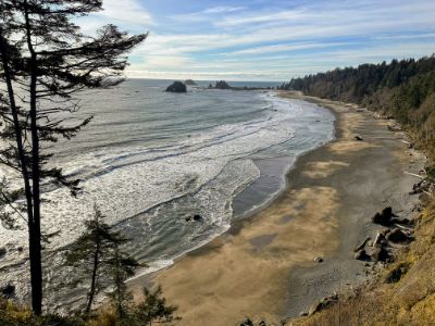
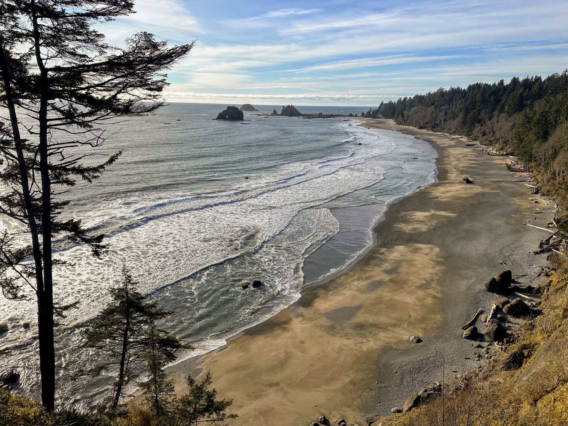
We started the morning at the Third Beach trailhead with an easy 1.3 miles of mostly flat trail before hitting some switchbacks to descend to the beach. It was a gorgeous sunny February day—the kind of weather that makes you grateful for Pacific Northwest winters.
The Real Adventure Begins
After a short beach walk, the trail ascended 200 feet via some very nice ladders. This was our first taste of the technical terrain that makes this trail special. We emerged into the forest for about a mile before returning to the beach.
Challenges and Surprises
The tide was high, forcing us to navigate uphill using ropes to bypass a coastal section. The descent on the other side was steep and unstable—this section had the deepest mud we encountered on the entire trail. Once we cleared it, we enjoyed a lovely section of beach walking (about 1 mile, best done with tides below 4.5 feet).
Scott's Bluff
We encountered another steep, muddy uphill section to leave the beach and re-enter the forest. This wooded section was mercifully short, and we quickly descended to Scott's Bluff camp. The camp had a nice outhouse, though there was a large pile of half-burnt garbage. A slippery driftwood pile crossed the creek, but it served as a useful crossing.
Final Push to Toleak
The next beach section (1.2 miles) is recommended for tides below 4 feet—we had the tide still going out, so we had easy conditions. The final approach to Strawberry Point featured rocky terrain with large boulders. Despite the slippery conditions, we made it through (grateful for trekking poles!) and could see why Strawberry Point looked like a nice camping option.
We pressed on to Toleak Point for our permitted camp. The bathroom is conveniently located on the north side of the point, while the water source is on the south side.
Evening: A relaxed and fun day! We made dinner on the beach while enjoying the views and mentally preparing for our long hike ahead.
Day 2: Toleak Point to Jefferson Bay and Back
We left our tent and extra gear and set off at sunrise for an ambitious day hike. The map promised just over 7 miles, but newer trail sections meant we actually hiked just over 8 miles each way (16 miles round trip).
The Journey Out
Leaving Toleak, we had pleasant beach walking before encountering ropes for a short uphill section. The first forest section (about a mile) involved two creek crossings:
- Falls Creek: Had a convenient fallen tree, though parts were slippery
- Goodman Creek: Larger and deeper with no logs across it. We waded through water that reached mid-thigh
The tide was still relatively high on the next beach section, forcing us to dodge waves. We walked a long beach stretch until Mosquito Creek, where timing was critical. The current was strong and water rose to high-thigh. Mosquito Creek camp sits on the cliff above with a hidden toilet—take the left fork when you see the split (don't follow the initial "Camp" sign) to stay on the nice trail around the facility.
The Long Forest Section
The longest forest section (3 miles) earned its reputation for mud, especially near Jefferson Bay. We were pleasantly surprised to find conditions normal compared to the previous day. Washed-out sections had new trails routed around them, which were fairly easy to navigate.
Jefferson Bay
We descended to Jefferson Bay via a lovely ladder. The tide remained high, limiting our exploration, but the views and sunshine made it worthwhile. We soaked in the peaceful atmosphere and then began our return, grateful that the lower tides made both the beach walking and Mosquito Creek crossing much easier on the way back.
Evening: Another lovely night at camp, watching eagles and listening to the waves.
Day 3: Toleak Point to Third Beach
Monday morning brought the forecast we'd been expecting: rain. It was only lightly misting as we broke camp at sunrise, but it quickly intensified. The tides were going to be tight, and rather than waiting for the ideal 3pm lowest tide window, we made an early push.
Racing the Tide
The first beach section past Strawberry Point was tricky, especially negotiating the rocky boulders. We kept a strong pace to Scott's Bluff, then immediately pushed through the next beach section. The tide was approaching 6 feet, and we definitely had to dodge waves, but we made it past the critical sections.
We kept going and made it back to Third Beach about 2 hours after leaving camp. The tide was rising rapidly, and we were grateful it wasn't any higher as we hiked the final stretch along the beach to get to the forest trail and then back to our car.
Trip Reflections
The South Coast Wilderness Trail is a truly beautiful coastal hike with pristine beaches, dramatic terrain changes, and excellent wildlife viewing opportunities. The tide-dependent nature of the trail adds both challenge and excitement. During peak season, it seems like this area can get quite busy, if all the permits were taken I think this area would be a bit chaotic!
Comparative Notes: We liked the South Coast slightly more than the North Coast Route. Both routes are absolutely worth doing if you get the chance. But we really enjoyed the beachs in the South. The north had quite a few beach sections that were a bit tiring to walk on (loose sand and lots of slippery rocks).