The Lost Coast Trail stretches 25 miles along the northern California coastline from Mattole to Black Sands Beach. It can be hiked either direction but if you hike south the wind will usually be at your back.
Tide Zones
There are three tide zones along this trail. You can use the Roam Trail Planner to calcuate when the tides are passable on your planned dates.
Zone 1
A short section before the Punta Gorda Lighthouse, roughly from 40.26534, -124.36202 to 40.26143, -124.36316. The recommendation is to cross this when the tide is below 5ft. We arrived a little early at 6ft and didn't have any issues but the waves were very small today. The tightest part of this zone is about 5ft on sand.
Zone 1 tide area
Zone 2
A four mile zone, it starts once you get back to the beach after Sea Lion Gulch camp (roughly 40.23986, -124.33153) and stretches all the way to Randall Creek (at about 40.20033, -124.28237). The tightest part of the zone was from about 40.20580, -124.29172 to Randall Creek. Recommended to cross this zone with a 2.5ft tide or lower. We got there a little early and had a 3.5ft tide, any higher and we would have been hiking through more of the annoying rocks. For the second half of zone 2 we had a 3ft tide and we were still able to cross but we did have to dodge a few waves. The waves were still calm today which helped.
Zone 2 rocky coastline
Zone 3
Another four mile zone starting after Miller Flat (roughly 40.12298, -124.16356) and ending at Gitchell Creek (at about 40.09417, -124.10195). The recommended tide height for this zone is below 3ft. By the time we made it here the tide was nice and low so I'm not sure how much earlier you could cross.
Zone 3 Approximate Tide Map
⚠️ All maps and coordinates are approximate. The tide zones can be very dangerous and hikers have died. Make sure to carefully plan your trip and while you hike watch for sneaker waves. Proceed at your own risk.
The Trail
Overview of the trail
Trail Stats: 25 miles 1,522ft of gain
Drive from Shelter Cove to Mattole
We decided to get a semi early start and arrived at the Mattole beach trailhead a little before 8am. Getting from Shelter Cove to Mattole takes just under 2 hours, but the roads are almost all paved and it went by quickly. There are also car camping sites at Mattole if you want to do the drive the day before. Pit toilets are also available at the trailhead. No parking permit required.
Getting Started
By 7:50am we were on the trail and the adventure began! The first few miles are on soft sand which was a little slow going. We saw a river otter and seals so that kept the trail interesting! You enter tide zone 1 pretty quickly but you could take an uphill trail around it (though it did look a bit overgrown). We were a bit early for their recommended tide height but we were able to easily get through this zone.
Sea lions on the beach
At Fourmile Creek you get a break from the sand and have a nice trail section past the lighthouse. Very nice running here. Saw lots of sea lions and had a short detour uphill to give them their space.
The Punta Gorda lighthouse was built in 1911 and was deactivated in 1951. In that time it hosted 7 keepers. The Fresnel lens can be viewed at the Maritime Museum in Eureka.
Getting close to the pinch point in zone 2
After Sea Lion Gulch campsite, tide zone 2 starts. There is a short stretch of rocks before getting to some nice sand. Follow a few posts uphill where you cross the Cooskie Spur Route. After a short uphill section you go back down and rejoin the beach. We made our way quickly to Cooskie Creek with a few more rocky sections here and there. After Cooskie is a nice stretch of sand and what we felt was the tightest pinch point in tide zone 2 (40.20376, -124.28980). A little rock hopping and timing the waves right and we made it out of the tide zone and to Randall Creek.
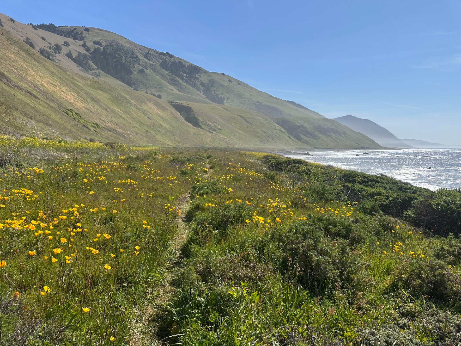
Another fast section of trail along Spanish Flats was a welcome change from the slower sand. The poppies were in full bloom, it was gorgeous! This was a very nice section of the trail to run. After going past a house the trail rejoins the beach, this section felt a bit slow especially the closer we got to the airstrip. Be careful though, we came very close to a sneaky rattlesnake hiding in the shade! Once you come around the corner and can see the houses/airstrip of Big/Miller Flats you could keep following the beach here or hop up on a trail, we picked the trail and quickly got to Big Flat camp. This was by far the busiest camping area with many people already setting up their tents as we were going past at 2pm. There were sections of nice trail here with some sandy trail mixed in.
Start of zone 3
Now begins tide zone 3, the tide was pretty far out so we had no challenges with this one. The hardpacked trail portions are now over, until Black Sands Beach it's a long stretch of hiking on sand. The sand here was mixed firmness and we ran a bit of it. Near Shipman Creek the tide was very far out and we stopped to look at all the starfish in the tidepools, I had never seen so many all together! The last few miles we were definitely feeling it. You can see Shelter Cove tantalizingly close, but at the same time still so far away. We kept up a good pace and reached Black Sands Beach at 4:30pm.
The hike for us wasn't quite done. Since we had left our car up north we now had to hike two extra miles to our hotel. The tide was still out so we stayed on the beach and hiked around the corner to Little Black Sands Beach and got on the road from there. A little bit of hiking on the road and we made it back to the hotel.
In the morning one of us would head back to Black Sands Beach Trailhead to get on the shuttle to go pick up the car at Mattole.
Enjoying the sunset lighting at the Black Sands Inn
Final Thoughts
Looking back on the trail from Black Sands Beach
Overall we enjoyed the trail much more than we thought we would! After just doing a backpacking trip on the Oregon Coast and not finding that to be the most fun I was a little worried about doing this trail. I really enjoyed that it wasn't all sand walking, the sections of trail felt so nice and fast. There were also lots of interesting terrain to look at, lots of animals and most of the beach sections didn't stretch on forever. I had read that the rocks on the beach could be challenging but I felt they were pretty easy especially compared to the Washington Coast. I brought poles but only really used them for balance when crossing the creeks. None of the creeks required taking shoes off. A fantastic day hike and perfect for trail running, I'd definitely recommend!
Logistics
Overnight Permits can be found on the BLM website here. Permits can be sold out well in advance so make sure to book yours early. No permits are needed to day hike the trail.
Water, I'm sure this hike gets very hot in the summer, there is very limited shade anywhere on the trail. Going in March there were lots of places to fill up water, we only carried 500ml at a time.
To book a shuttle visit Lost Coast Adventure Tours. Their shuttles run twice a day at 7AM and 12:30PM and will pick you up at Black Sands Beach and drop you off at Mattole Trailhead.
Bear cans are also required. If you need to rent one there are two options. If you're taking the shuttle you can get a bear can from Lost Coast Adventure for $22 or from the BLM office for $5 (they can run out though and they can't be reserved in advance). If you have your own make sure it's on the approved list.
Dogs are allowed on the trail but the hot black sand and sharp rocks can be pretty hard on their feet. Between Punta Gorda and Sea Lion Gulch dogs need to be leashed due to a large sea lion colony.
There are many camps along the trail, tried to get photos of most of them! Most sites have nice water sources but a few were up on the bluffs and some around Wolfman were away from water. There are a few sections of private property so be sure to avoid those.
Sea Lion Gulch
40.24000, -124.33198
Sea Lion Gulch camp
Camp Spot close to Cooskie Spur Route Trail
40.23373, -124.32478
Camp spot near Cooskie Spur Route Trail
Cooskie Creek Camp
40.21927, -124.30965
Cooskie Creek Camp
Randall Creek
40.20062, -124.28225
Randall Creek
Randall Creek campsite on the bluffs
Camp Wolfman
40.18993, -124.26476 — Lots of campsites in this area
Camp Wolfman
Spanish Flats Area
40.18648, -124.25851 — Lots of campsites in the area
Spanish Flats area camp
Kinsey Creek
40.17202, -124.22958
Big Creek
40.15690, -124.21069
Miller/Big Flats Area
40.12783, -124.17447 — By far the busiest area, lots of campsites.